Peta merupakan salah satu instrumen perencanaan yang penting dalam pengembangan desa dan kawasan pedesaan. Undang-Undang Republik Indonesia Nomor 6 Tahun 2014 Tentang Desa telah mengamanatkan bahwa batas wilayah desa dinyatakan dalam bentuk peta desa yang telah ditetapkan dalam peraturan Bupati/Walikota. Pada praktiknya, pemetaan desa telah melibatkan masyarakat terutama dalam penentuan batas-batas desa. Hanya saja, masih timbul banyak tantangan terkait dengan peta dan pemetaan desa, yakni (1) banyaknya jumlah desa di Indonesia yang belum jelas batas administrasinya, (2) konflik antar desa terkait batas yang masih berlangsung, dan tantangan teknisnya (3) citra satelit yang digunakan sebagai dasar pemetaan desa kualitasnya rendah (tutupan awan, waktu pengambilan citra yang tidak berkala, resolusi rendah). Tiga hal tersebut merupakan tantangan yang harus dijawab bersama baik oleh pemerintah maupun masyarakat sipil untuk menghindari konflik yang berkepanjangan terkait dengan persoalan ruang dan pemanfaatannya.
Untuk menjawab tantangan-tantangan tersebut, Kemitraan telah menginisiasi Akademi Drone dan Data Desa pada 9-12 Mei 2018 di Jambi. “Akademi drone diadakan karena kami melihat ada kebutuhan yang sangat tinggi, tidak hanya untuk pemetaan wilayah, tetapi juga untuk pemantauan kegiatan, pemanfaatan lahan maupun bentang lahan, seperti untuk contohnya agrikultur, kehutanan, dan ekosistem gambut. Jadi memanfaatkan drone sebagai alat pemantauan pembangunan di tingkat desa. Keluaran dari pelatihan ini adalah desain pelatihan drone yang lebih terstruktur, jelas metode pembelajarannya, dan tentunya ada modul untuk menjadi pedoman pelatihan berikutnya” tutur Hasantoha Adnan selaku Project Manager Desa Peduli Gambut dari Kemitraan. Metode yang digunakan dalam pelatihan ini adalah metode pelatihan partisipatif di mana peserta dan fasilitator/narasumber saling berbagi pengetahuan dan pengalaman.
Hasil dari kegiatan kali ini adalah desain proses pelatihan yang berstruktur, jelas metode pembelajaran dan materinya, serta sederhana dalam penyampaian, dan juga menghasilkan modul yang nantinya akan digunakan sebagai pedoman dalam pelatihan berikutnya. “Modul Akademi Drone diharapkan bisa digunakan (reusable) dan direplikasi (replicable) oleh masyarakat dalam lingkup yang lebih luas,” lanjut Hasantoha. Tujuan dari akademi drone sendiri adalah melatih para pegiat atau aktifis desa agar memanfaatkan teknologi drone untuk menghasilkan data spasial yang akurat dan presisi tinggi.
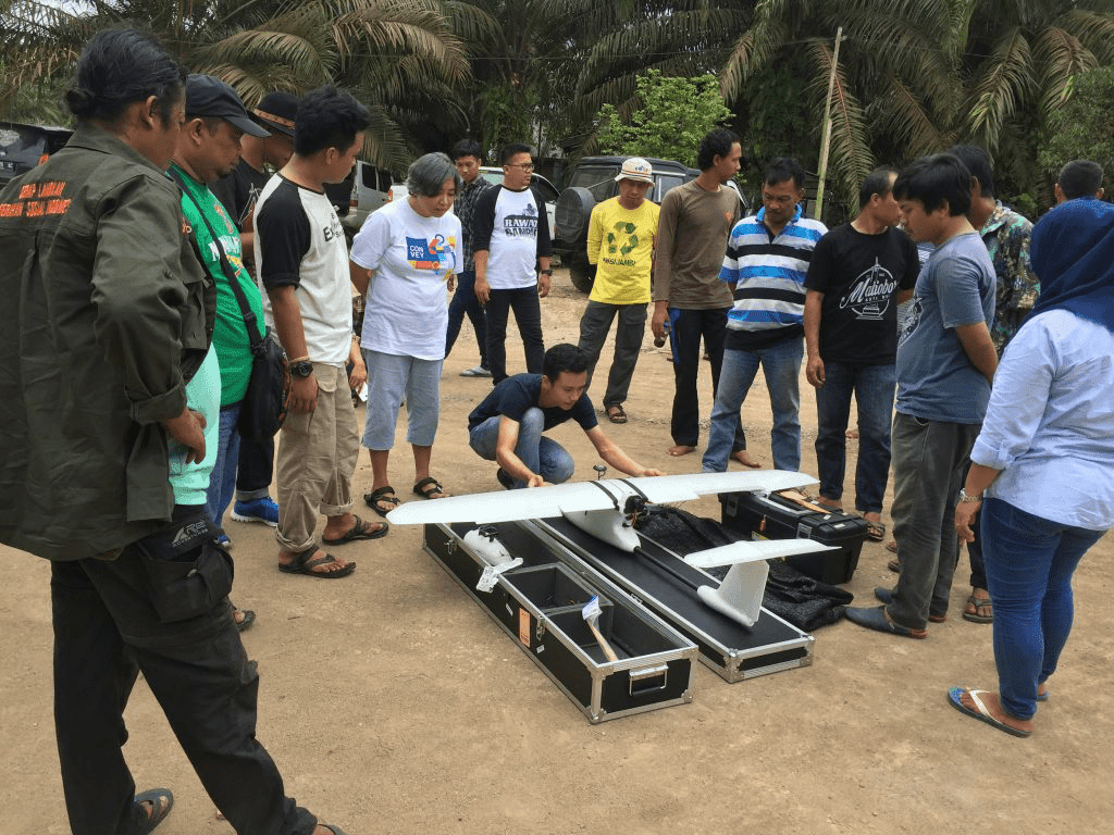
“Kami melatih peserta mulai dari menerbangkan drone, memotret lahan untuk pemetaan partisipatif yang kemudian hasilnya disatukan dan dianalisis. Data tersebut diharapkan nantinya bisa digunakan dalam berbagai konteks, seperti perencanaan desa, agrikultur, dan pemantauan wilayah,” kata Irendra Radjawali sebagai fasilitator di Akademi Drone. Di hari ketiga, peserta diajak ke lapangan untuk mempelajari lebih lanjut tentang jenis drone multirotor (copter) dan fixed-wing untuk memetakan wilayah hutan dan lahan masyarakat di Desa Pandan Sejahtera, di Kabupaten Tanjung Jabung Timur, Jambi. Drone fixed-wing digunakan untuk melihat areal bekas lahan HTI yang ternyata merupakan kawasan gambut dalam.
Tak hanya berlatih menerbangkan dan menganalisis data, kedepannya peserta juga akan diajarkan untuk “mengoprek” kamera Red Green Blue (RGB) biasa menjadi kamera Near Infra Red (NIR) sehingga dapat menghasilkan citra Near Infra Red yang dapat dikembangkan menjadi citra Normalized Difference Vegetation Index (NDVI) yang dapat mengidentifikasi tingkat stress individu-individu tanaman. “Untuk melakukan pemetaan pada sebuah lahan, dulu kita harus berkeliling atau menunggu hasil dari satelit, kini sudah ada drone yang bisa dioperasikan secara autopilot dan memudahkan pekerjaan di lapangan. Kita hanya perlu duduk manis, gambar lahan sudah didapat dan tinggal dianalisis,” kata Anto salah satu peserta Akademi Drone dari Bulukumba, Sulawesi Selatan. Ia juga berharap ke depannya ada pelatihan “mengoprek” kamera drone yang dilengkapi dengan sensor cuaca sehingga masyarakat bisa memantau cuaca di daerah masing-masing. Di akhir pelatihan, Roem Topatimasang selaku penggiat sosial dari INSIST mengingatkan bahwa, “penggunaan drone bukan hanya sebatas memanfaatkan kecanggihan teknologi, tapi juga harus dibarengi dengan etika dan tanggung jawab sosial dalam penggunaannya, karena pada akhirnya penggunaan drone harus mendukung kedaulatan atas data dan ruang hidup rakyat.”