Map is an important planning instrument in the development of villages and rural areas. The Law of the Republic of Indonesia Number 6 of 2014 concerning Villages has mandated that the boundaries of the village area are stated in the form of a village map that has been stipulated in the Regent/Mayor regulation. In reality, village mapping has involved the community, especially in determining village boundaries. However, there are still many challenges related to village maps and mapping, (1) the large number of villages in Indonesia whose administrative boundary is not yet clear, (2) conflicts between villages related to boundaries that are still ongoing, and technical challenges (3) the satellite imagery used as a basis for village mapping has a low quality (cloud cover, irregular image capture time, low resolution). These three things are challenges that must be answered jointly by both the government and civil society to avoid prolonged conflicts related to the issue of space and its usage.
To answer those challenges, KEMITRAAN has initiated the Drone Academy and Village Data on May 9-12th 2018 in Jambi. “The drone academy was held because we saw a very high need, not only for mapping the area, but also for monitoring activities, land use and landscapes, such as for example agriculture, forestry, and peat ecosystems. So drones are used as a monitoring tool for development at the village level. The output of this training is more structured drone training design, clear learning methods, and of course there are modules to guide the next training,” said Hasantoha Adnan as Project Manager of the Peat Care Village from KEMITRAAN. The method used in this training is a participatory training method in which participants and facilitators/resources share knowledge and experiences.
The result of this activity is the design of a structured training process, clear learning methods and materials, simple way of learning, and also produces modules that will later be used as guidelines in the next training. “The Drone Academy module is expected to be reusable and replicated by the wider community,” Hasantoha continued. The aim of the drone academy itself is to train village activists or activists to use drone technology to produce accurate and high-precision spatial data.
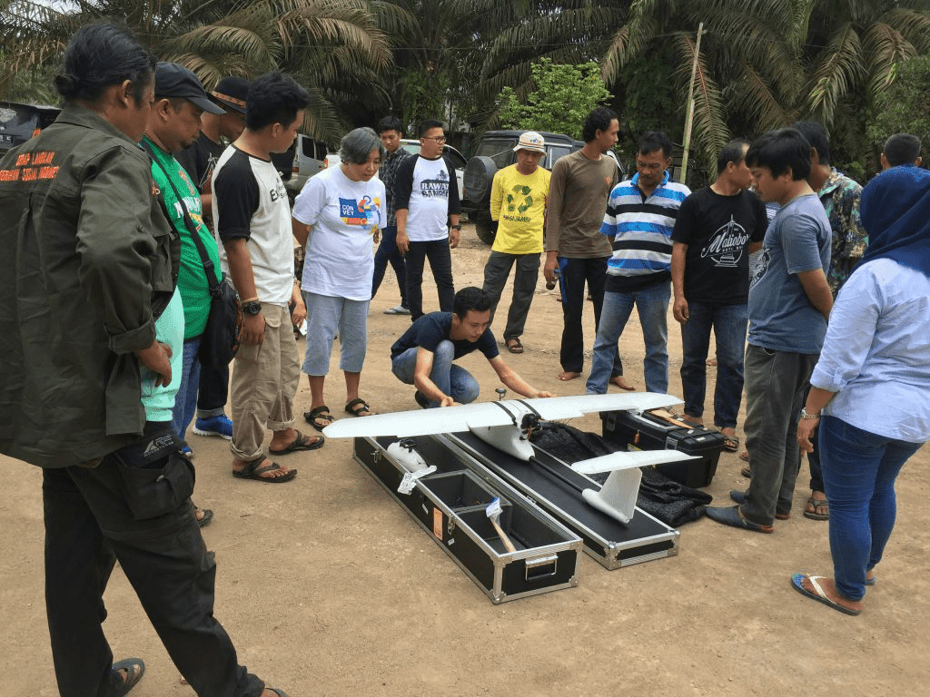
“We train participants from flying drones, photographing land for participatory mapping, then the results are put together and analyzed. The data hopefully can later be used in various contexts, such as village planning, agriculture, and regional monitoring,” said Irendra Radjawali as the facilitator at the Drone Academy. On the third day, participants were invited to the field to learn more about the types of multirotor (copter) and fixed-wing drones to map forest areas and community land in Pandan Sejahtera Village, Tanjung Jabung Timur Regency, Jambi. Fixed-wing drones were used to see areas of former HTI land which turned out to be deep peat areas.
Not only practicing flying and analyzing data, in the future, participants will also be taught to “repair” ordinary Red Green Blue (RGB) cameras into Near Infra Red (NIR) cameras so that they can produce Near Infra Red images that can be developed into Normalized Difference Vegetation Index images. (NDVI) which can identify the stress level of individual plants. “To do mapping on land, we used to have to go around or wait for the results from the satellite, now there are drones that can be operated on autopilot and make work in the field easier. We just need to sit back, we’ve got a picture of the land and we just need to analyze it,” said Anto, one of the participants from the Drone Academy from Bulukumba, South Sulawesi. He also hopes that in the future there will be training to “operate” drone cameras equipped with weather sensors so that people can monitor the weather in their respective areas. At the end of the training, Roem Topatimasang as a social activist from INSIST reminded that, “the use of drones is not only limited to utilizing technological sophistication but must also be accompanied by ethics and social responsibility in its use, because in the end the use of drones must support sovereignty over data and other’s living space.”